
China Accelerates South China Sea Build-Up
New installations on Yagong Reef islet signal China's expanding military footprint in the Paracel Islands and its tightening grip on the northern South China Sea.
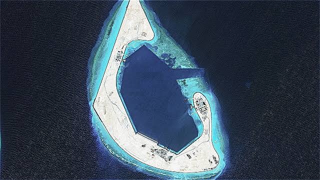
New Installations Detected on Yagong Reef
Satellite imagery dated August 17, 2026, has revealed newly erected structures on Yagong Reef, a feature within the Crescent Group of the Paracel Islands in the northern South China Sea. The imagery, sourced from commercial satellite operator Vantor, shows construction activity approximately 14 kilometres northeast of concurrent build-up on Antelope Reef — a proximity that analysts assess as deliberate and strategically coordinated. Independent analysts have assessed the new structures as potentially consistent with early-warning radar or sensor arrays, marking a significant escalation in China's South China Sea build-up within a sector that had previously seen comparatively limited development.
The discovery reinforces a well-documented pattern of incremental Chinese construction across disputed maritime features, and is expected to intensify diplomatic friction with rival claimants and major maritime powers alike.
What the Satellite Imagery Shows
The Vantor-sourced imagery captures multiple newly erected structures whose dimensions, orientation, and positioning are consistent with sensor or radar infrastructure rather than purely civilian administrative facilities. Analysts note that the pace and apparent pre-planning of the construction — evidenced by the simultaneous activity at nearby Antelope Reef — suggests a coordinated, pre-authorised deployment rather than improvised or reactive development. The structures' configuration has drawn particular attention given their potential to extend China's maritime domain awareness capabilities northward across the Paracel archipelago.
Proximity to Antelope Reef Build-Up
Yagong Reef's location 14 kilometres northeast of Antelope Reef, where separate construction activity has been documented concurrently, points to a deliberate effort to establish an interlocking network of installations across the Crescent Group. Geographic clustering of this nature is a recognised hallmark of China's layered area-denial and maritime domain awareness strategy, in which individual installations mutually reinforce one another's sensor coverage, communications reach, and defensive depth. Taken together, the two sites suggest Beijing is methodically filling gaps in its surveillance and control architecture across the northern Paracels.
Strategic Significance of the Paracel Islands
The Paracel Islands occupy a commanding position in the northern South China Sea, straddling critical international shipping lanes through which an estimated $3 trillion in global trade transits annually. The archipelago is administered by China but claimed in whole or in part by Vietnam and Taiwan. China seized full control of the island chain from South Vietnam in January 1974, following a brief but decisive naval engagement, and has since invested heavily in militarising its features.
The Crescent Group, the western sub-cluster of the Paracels where Yagong Reef is situated, offers particular strategic reach toward the Vietnamese coastline and the Gulf of Tonkin. Installations in this sub-group complement the more extensively developed eastern features, including Woody Island (Yongxing), which serves as the administrative and military hub of China's Paracel presence and hosts an airstrip, harbour facilities, surface-to-air missile batteries, and advanced radar systems. Any expansion of sensor infrastructure in the Crescent Group would meaningfully extend the coverage envelope already anchored at Woody Island.
China's Expanding Military Footprint: A Pattern of Escalation
Beijing's construction activities across the South China Sea have followed a consistent and well-documented trajectory since at least 2013. The progression has moved from initial land reclamation on submerged or semi-submerged reefs, to the construction of runways, deep-water harbours, and hardened hangars, and ultimately to the installation of missile batteries, electronic warfare systems, and radar arrays across both the Paracel and Spratly island chains. The new Yagong Reef installations fit squarely within this pattern of incrementally expanding military-grade infrastructure, frequently introduced under the characterisation of civilian or administrative use before being upgraded to overtly military functions.
International observers — including the United States, the Philippines, Japan, Australia, and multiple ASEAN member states — have repeatedly condemned such activities as destabilising and inconsistent with international law, including the United Nations Convention on the Law of the Sea (UNCLOS).
Dual-Use Infrastructure and Early-Warning Capabilities
Should the structures on Yagong Reef be confirmed as early-warning radar facilities, they would extend China's sensor coverage northward across the Paracel archipelago, complementing the already substantial surveillance infrastructure on Woody Island. Such a capability would enhance Beijing's ability to monitor air and maritime traffic across a vast swathe of the northern South China Sea, including approaches to the Gulf of Tonkin and flight paths toward Hainan Island, home to a major People's Liberation Army Navy submarine base. The strategic value of persistent, wide-area domain awareness in this corridor is considerable, both for defensive early warning and for the projection of offensive maritime power.
Militarisation Despite Diplomatic Assurances
China has consistently maintained that its South China Sea activities are defensive and sovereign in nature, framing construction on disputed features as the legitimate development of Chinese territory. Beijing has also argued that its installations contribute to regional public goods, including maritime search-and-rescue and meteorological services. However, independent satellite monitoring conducted by organisations including the Asia Maritime Transparency Initiative (AMTI) at the Center for Strategic and International Studies has consistently documented the installation of military-grade assets — including radar systems, weapons emplacements, and military-capable runways — that extend well beyond any plausible civilian justification. This persistent gap between official statements and observable facts has deepened mistrust among claimant states and major maritime powers, and has complicated efforts to negotiate a binding Code of Conduct for the South China Sea under ASEAN auspices.
Regional and International Reactions
The latest developments on Yagong Reef are expected to intensify diplomatic friction between China and rival claimants Vietnam, the Philippines, Malaysia, and Brunei, each of which maintains overlapping claims in the South China Sea. Vietnam, which contests Chinese control of the Paracels most directly, has historically lodged formal diplomatic protests in response to Chinese construction activity in the archipelago. The Philippines, emboldened by a landmark 2016 arbitral tribunal ruling under UNCLOS Annex VII that invalidated China's expansive "nine-dash line" maritime claims, has grown increasingly assertive in challenging Chinese activities, particularly in the Spratly Islands.
The United States, which takes no position on the underlying sovereignty disputes but asserts the right of all nations to freedom of navigation and overflight, conducts regular Freedom of Navigation Operations (FONOPs) in the South China Sea. Washington has signalled that it views Chinese militarisation of disputed features as a direct challenge to the rules-based international order and to its treaty commitments to the Philippines under the 1951 Mutual Defense Treaty.
ASEAN as a body has struggled to forge a unified response to Chinese activities, hampered by the divergent economic dependencies of individual member states on Beijing. Countries such as Cambodia and Laos have historically resisted ASEAN consensus statements that directly criticise China, limiting the bloc's collective leverage. Negotiations over a Code of Conduct for the South China Sea have proceeded slowly, with critics arguing that Beijing has used the process to delay binding constraints on its behaviour while consolidating facts on the ground.
Outlook: Implications for South China Sea Stability
The acceleration of Chinese construction on previously undeveloped or lightly developed features such as Yagong Reef indicates that Beijing is moving to consolidate its strategic position in the northern South China Sea, potentially ahead of any renewed diplomatic negotiations or legal challenges. Analysts warn that each new installation incrementally raises the cost — military, political, and reputational — of any future challenge to China's de facto control, progressively narrowing the window for a negotiated diplomatic resolution.
The trajectory of events points toward a more contested and potentially volatile maritime environment in the near to medium term. As China's sensor and denial networks become more densely interlocked across both the Paracel and Spratly chains, the operational space available to rival claimants and external powers diminishes. For regional governments and international stakeholders, the Yagong Reef developments serve as a further indicator that the strategic competition over the South China Sea is intensifying, not abating.
Disclaimer: This article is intended for informational purposes only and does not constitute investment advice. References to geopolitical developments may affect financial markets and asset valuations; readers should conduct independent due diligence before making any investment decisions.
UCapital Asset Management LLP or group companies may have commercial relationships with the companies mentioned. This content is not financial advice.
Sign up for free to ask the AI about this article.
Elections, tariffs, sanctions and reforms: what changes for markets, countries and supply chains.